Lycian Way: Turkey's 540km Coastal Trekking Route (Complete Guide)
Contents
- The Trail: Overview
- Difficulty
- Best Sections for Shorter Trips
- Ölüdeniz to Faralya (4km, 3–4 hours, challenging)
- Ölüdeniz to Kabak (approximately 30km, 2–3 days)
- Kabak to Alınca (remote, camping required on some stretches)
- Kalkan to Kaş (approximately 30km, 2 days)
- Kaş to Üçağız to Kekova (approximately 40km, 2–3 days)
- Finike to Olympos (approximately 60km, 3–4 days)
- Season
- Accommodation
- Costs
- Getting There
- Navigation Tools
- Guided Treks
The Lycian Way runs 540km along the southwestern coast of Turkey between Fethiye and Antalya, crossing the ancient homeland of the Lycians — a people who carved their tombs directly into cliff faces and left ruins scattered across more of the landscape than any comparably sized territory in Anatolia. The trail was researched and waymarked by British travel writer Kate Clow, based in Turkey, and first published as a guidebook in 1999. It is now one of the finest long-distance walking routes in the Mediterranean.
Most people who come to walk the Lycian Way choose a section of 3–10 days. This guide covers the full trail, the best individual sections, practical logistics, accommodation, costs, and what to expect underfoot.
The Trail: Overview
Total length: approximately 540km
Full duration: 25–35 days end-to-end
Direction: most people walk from Fethiye east to Antalya (Ovacık trailhead), though the reverse is equally feasible
Official name: Likya Yolu (Turkish)
Waymarking: red and white painted blazes on rocks and trees; metal directional signs at key junctions
Terrain: a mix of ancient Lycian paths, Roman-era flagstone roads, limestone coastal tracks, forest trails, village tracks, and beach crossings
The trail covers genuinely varied ground. Some sections walk at near sea-level along turquoise coves. Others climb 600–900m in a single day on exposed limestone ridges with views across the Mediterranean. Difficulty ranges from straightforward to strenuous depending on the section.
Difficulty
The Lycian Way is not a technical trail — no via ferrata, no glacier crossings — but it should not be underestimated. Three factors account for most difficulties:
Heat: coastal sections in July and August regularly exceed 35°C. Exposed ridge sections, particularly near Alınca and the Tahtalı mountain area, can be dangerous in midsummer. This is the primary reason season selection matters more than on most European trails.
Elevation: several sections involve steep ascents and descents on loose limestone. The Ölüdeniz to Kabak section includes a descent of approximately 400m elevation loss over a short distance — hard on knees. The Finike to Antalya section involves sustained limestone karst climbing.
Water: springs marked on the Lykia Yolu app are the lifeline on remote sections, but many are seasonal. In late September and October some run dry. Carrying 3–4 litres between known sources is the minimum in spring; more in summer.
A GPS navigation app is essential — the waymarking is generally good but some forest and landslide sections are ambiguous. The Lykia Yolu app is the standard tool (see Navigation below).
Best Sections for Shorter Trips
Ölüdeniz to Faralya (4km, 3–4 hours, challenging)
The opening section of the trail from the western end and the most dramatic short stretch on the entire route. From Ölüdeniz the path climbs steeply to the clifftops above Butterfly Valley (Kelebekler Vadisi) — 400m above sea level with the Blue Lagoon visible below. The trail is exposed in parts and requires care, but the views are extraordinary.
Faralya is a small village above Butterfly Valley with a handful of guesthouses and a celebrated pansiyon terrace looking directly down into the gorge. A natural overnight stop.
Logistics: Fethiye → dolmuş to Ölüdeniz (20 minutes, approximately ₺20–30 as of 2026). Faralya to Fethiye by dolmuş (less frequent — confirm times locally).
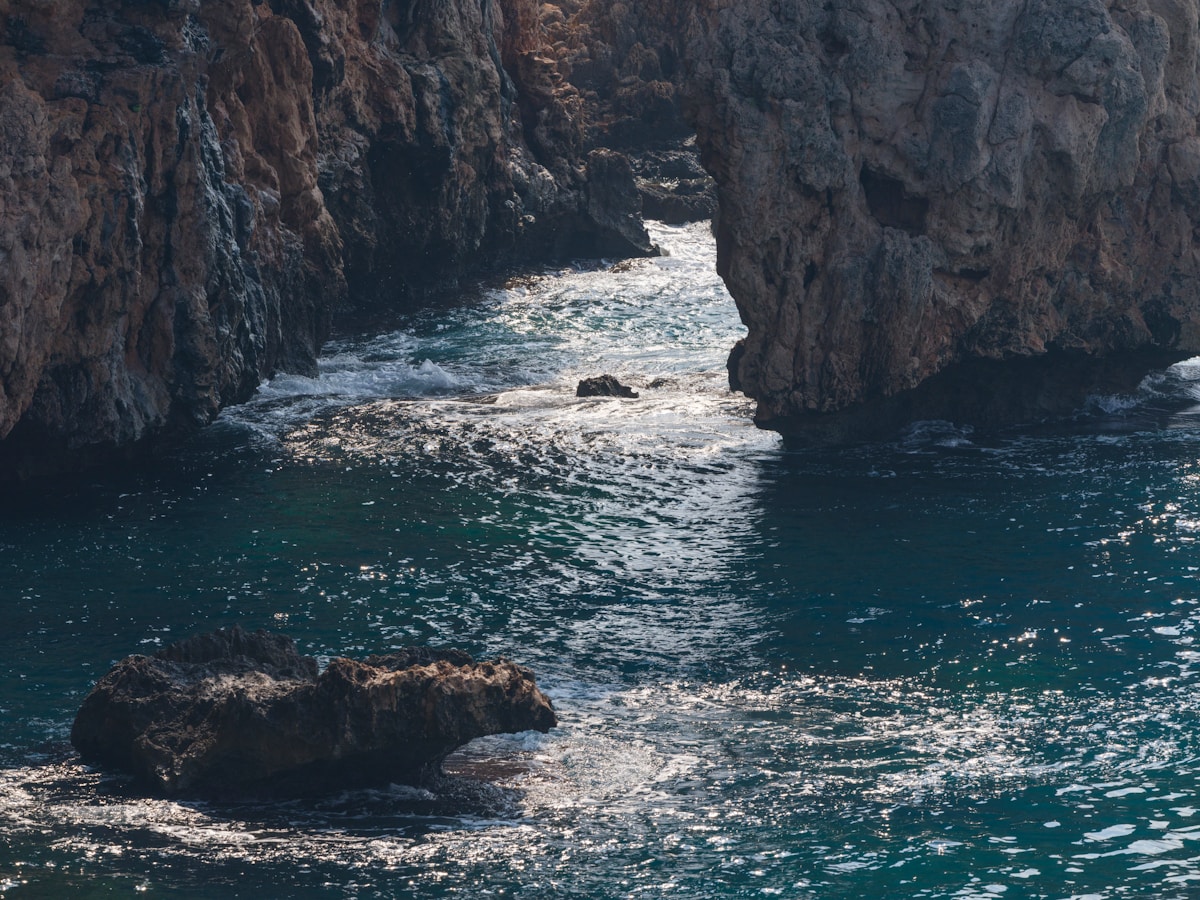
Ölüdeniz to Kabak (approximately 30km, 2–3 days)
The best introduction to the trail overall. Starting from Ölüdeniz, the route follows the clifftops above Butterfly Valley with views over the lagoon and the deep gorge below, then descends through forested terrain toward the remote beach at Kabak. Kabak is a small community of eco-camps and pansiyons accessible only on foot or by water taxi — no road reaches it.
Accommodation along section: Ölüdeniz (extensive), Faralya (pansiyons), Kabak beach (eco-camps and simple guesthouses). Approximately ₺500–800 per person per night with breakfast as of 2026.
Kabak to Alınca (remote, camping required on some stretches)
The section east of Kabak is the most remote and physically demanding stretch of the western trail. The path crosses ridgelines with sweeping views back over the coast and descends through forested canyons. Water sources are sparse. Some hikers combine this with a night of camping rather than relying on village accommodation, though a simple guesthouse at Alınca marks the end of the hardest stretch.
Recommended only for experienced trail walkers with good navigation skills and GPX downloaded.
Kalkan to Kaş (approximately 30km, 2 days)
A gentler section following the sea and passing through or near several small villages. Both towns at either end have good accommodation, restaurants, and bus connections. Kalkan is a small cliff-side town with good cafés; Kaş is the most developed base on the mid-trail section with a famous Lycian sarcophagus standing in the middle of a street.
Kaş to Üçağız to Kekova (approximately 40km, 2–3 days)
The best ruins section of the entire trail. From Kaş, the path winds through olive groves and coastal limestone to Üçağız and the Kekova area. The highlight is Batık Şehir — the sunken Lycian city at Kekova — where streets, staircases, and walls are visible beneath the clear water from the coastal path above. Boat tours from Üçağız give a closer view (approximately ₺200–350 per person as of 2026).
Simena (Kaleköy): a tiny village accessible only by foot or boat, built on and around Lycian ruins. The hilltop castle above offers exceptional views across the Kekova lagoon. One of the most photogenic points on the entire trail.
Logistics: Kaş is 3 hours by bus from Fethiye (Pamukkale or Metro Turizm intercity coaches). Üçağız has small pansiyons; minibus connections from Üçağız to Kaş are infrequent — check locally.
Finike to Olympos (approximately 60km, 3–4 days)
The trail’s eastern middle section passes through fragrant forest and approaches the Olympos ruins, a largely unexcavated Lycian city in a forested gorge leading to a beach. Entry fee to the Olympos site: approximately ₺120–150 as of 2026. This section is less walked than the western sections and the trail is quieter.
Season
March to May: the best months overall. Wildflowers bloom across the limestone, temperatures are mild (18–26°C on the coast), and the trail towns have none of the summer pressure. The sea is too cold for swimming (14–18°C) but the hiking is superb.
October to November: the second best window. The sea is still warm from summer (22–25°C), the light is exceptional, and most trail towns are quiet. Some higher sections can see rain from late October — check forecasts before ridge sections.
June: warm and increasingly hot. Coastal sections are getting uncomfortable by midday. Manageable with early starts (depart by 6–7am), but July–August conditions approach fast.
July–August: not recommended for sustained walking. Heat on exposed coastal sections is genuinely dangerous and heat exhaustion is a real risk. If you walk in summer, restrict to shaded forest sections and start no later than 7am.
December to February: possible on low-elevation coastal sections in fine weather but rain is common.
Accommodation
Village pansiyons and family guesthouses are the standard accommodation along the trail. Prices are modest throughout:
- Simple pansiyon room with breakfast: approximately ₺500–1,000 per night as of 2026
- Eco-camp platform tent or tree house (Kabak area): approximately ₺300–600 per person
- Wild camping: generally tolerated on open land away from villages, though fires are prohibited at all times
Booking ahead is advisable in May and October on the most popular western sections. Ölüdeniz–Kabak accommodation fills early during peak spring weeks.
Costs
Daily costs on the trail are modest by European standards:
- Accommodation: approximately ₺500–1,000/night
- Food in village restaurants and pansiyons: approximately ₺150–300/day
- Water from village shops: approximately ₺20–40 per 1.5L bottle
- Site entry fees (Patara approximately ₺120–150, Olympos approximately ₺120–150, Kekova boat tour approximately ₺200–350): plan these as separate line items
A typical daily budget all-in: approximately ₺1,000–1,500 as of 2026 for a solo walker. All prices approximate — verify locally.
Getting There
Fethiye (western trailhead): served by intercity buses from Istanbul (approximately 12 hours, Metro Turizm or Pamukkale), Antalya (approximately 3 hours), and by dolmuş from Dalaman Airport (approximately 50 minutes). Fethiye is the natural base for starting the Ölüdeniz section.
Antalya (eastern trailhead): Antalya Airport (AYT) is a major hub with direct flights from across Europe and domestic connections from Istanbul. City bus terminal connects to Finike, Kaş, and Fethiye.
Between sections: dolmuş (shared minibuses) connect most trailhead towns. Fethiye–Ölüdeniz, Fethiye–Kalkan, Fethiye–Kaş all have regular connections. Kaş–Üçağız is infrequent — ask locally for current schedules.
Navigation Tools
Lykia Yolu app (iOS and Android): the essential tool. Downloadable GPX tracks for every section, marked springs, accommodation points, and junction waypoints. Download the sections you need before leaving wifi. Free or minimal cost.
Kate Clow guidebook (The Lycian Way, latest edition): the authoritative text reference, written by the person who created the route. Detailed section-by-section descriptions with cultural and historical context. Worth carrying even alongside the app.
Komoot and Wikiloc both have user-uploaded GPX tracks for Lycian Way sections — useful as a cross-reference for confirming waymarked routes after landslides or rerouting.
Guided Treks
For those who prefer logistics handled, Bougainville Travel (based in Kaş) is the most established Lycian Way operator. They offer both guided and self-guided packages on the classic sections, with accommodation pre-booked, luggage transfers, and local guides. Kate Clow has worked with this operator. Guided packages for 5–7 day sections typically cost approximately €700–1,500 per person including accommodation and most meals — verify inclusions.
Middle Earth Travel (based in Göreme) offers some Lycian Way packages alongside their Cappadocia trekking focus — worth comparing for Kaş-centred sections.
The western trailhead is at Ölüdeniz, near Fethiye. The eastern terminus is Antalya. The route’s best-known midpoint is Kaş, which has the best range of accommodation for multi-day trekkers. For an overview of the full paragliding experience above Ölüdeniz at the trailhead, see our activity guide.
Essential extras: An eSIM for Turkey from Airalo gives you mobile data from the moment you land — no airport SIM queue, no physical card. Travel insurance for Turkey should cover medical costs; Turkish private hospitals charge full rates for uninsured visitors.
See also: Kaş travel guide · Patara beach and ruins guide · Fethiye travel guide · Turkish Riviera road trip · Turkey packing list
Book an experience
Top tours to book now
Already planning? These are the most popular experiences for this destination.
Frequently Asked Questions
- How long does it take to walk the entire Lycian Way?
- Walking the full 540km end-to-end takes approximately 25–35 days at a comfortable pace of 15–25km per day. Most people choose a specific section of 3–10 days rather than the full trail.
- Is the Lycian Way well waymarked?
- Generally yes — red and white painted blazes on rocks and trees throughout. Some remote sections can be faint or overgrown, particularly outside the spring season. The Lykia Yolu app (iOS and Android) with downloadable GPX tracks is the most reliable navigation tool; using it alongside the Kate Clow guidebook is strongly advised.
- Can I walk the Lycian Way without camping?
- Yes. The trail passes through enough villages with pansiyons to make hut-to-hut trekking viable on the most popular sections. You'll need to plan daily stages to end at villages with accommodation. The Lykia Yolu app shows accommodation options along each section.
- What is the best season for the Lycian Way?
- March to May is the best window: wildflowers, mild coastal temperatures, and almost no crowds. October and early November are the second choice — the sea is still warm from summer, the crowds have thinned, and the light is exceptional. July and August are too hot for sustained coastal walking and not recommended.
- What is the best section of the Lycian Way for first-timers?
- The Ölüdeniz to Kabak section (approximately 30km, 2–3 days) is the most popular starting point — dramatic coastal scenery above Butterfly Valley, clear waymarking, and straightforward dolmuş connections from Fethiye at both ends.