Hiking Near Gaziantep 2026: Euphrates Valley, Zeugma Plateau and Regional Day Trips
Book an experience
Top-rated experiences in Gaziantep Travel Guide
The highest-rated tours and activities in Gaziantep Travel Guide. Book today, cancel free if plans change.
Gaziantep is not primarily a hiking destination — the immediate surroundings are urban and agricultural rather than mountain terrain. However, the Euphrates River valley (90km east), the limestone hills south of the city, and the broader southeastern Anatolian plateau provide accessible walking with historical and landscape interest.
The most compelling reason to walk near Gaziantep is not the terrain but the historical landscape — the Euphrates crossings, the ancient settlements visible from every hillside, and the specific quality of the light on the Mesopotamian plain.
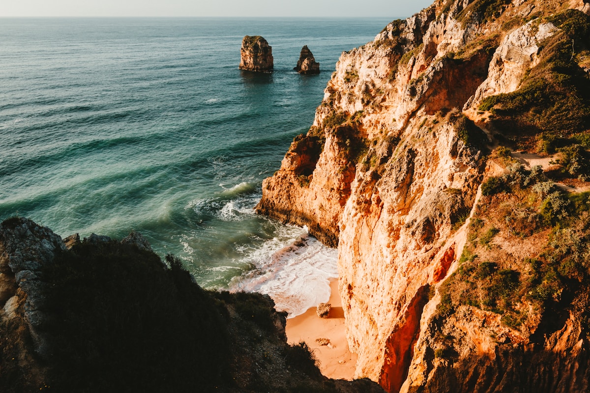
Euphrates River valley near Zeugma
Distance: 90km east of Gaziantep (Birecik town on the Euphrates).
The Euphrates near Birecik and the Zeugma site area — the river valley is dramatic, carved into the limestone plateau. The reservoir created by the Birecik Dam has transformed the landscape; the submerged portion of ancient Zeugma is visible (and accessible by boat) when the water is clear.
Walking options: River valley paths along the eastern bank north of Birecik; 5–10km circuits in the limestone cliff terrain above the river. 2–4 hours.
Bald ibis (Kelaynak) colony at Birecik: The Birecik bald ibis colony is one of the world’s last wild colonies of the northern bald ibis — a critically endangered species. The colony (February–August nesting season) is a 15-minute walk from the town centre. Worth combining with the Zeugma visit.
Access: Bus or car from Gaziantep to Birecik (1.5 hours).
Nizip area (near Zeugma)
Distance: 60km east of Gaziantep.
The limestone hills around Nizip have archaeological site trails — the Bronze Age and Iron Age settlements visible as mounds (höyük) across the plateau, the Araban area castle ruins, and the general historical landscape of the Gaziantep plateau.
Character: Open plateau walking; the archaeological mounds rising from the wheat fields; occasional shepherd communities. Best in spring (April–May) for wildflowers.
Islahiye plateau (south of Gaziantep)
Distance: 80km south, toward the Syrian border.
The Islahiye plain and the limestone hills north of the border have walking terrain — less visited, more remote, with the specific landscape of the southern Anatolian plateau approaching the Syrian agricultural zones.
Access: Car or bus to Islahiye (1.5 hours), then local exploration.
Şanlıurfa and Göbeklitepe (extended day trip)
Distance: 160km east (2.5 hours by car).
Göbeklitepe — the 12,000-year-old temple complex that rewrote the prehistory of human civilisation — is a full day trip from Gaziantep. The site (UNESCO World Heritage, 2018) consists of T-shaped megalithic pillars with carved animal reliefs, arranged in circles — built by hunter-gatherers approximately 6,000 years before Stonehenge.
Hiking at Göbeklitepe: The site itself is a 2–3 hour walk-and-look visit. The surrounding plateau terrain is accessible for additional walking.
Combined with Şanlıurfa: Şanlıurfa (Urfa) city has significant monuments (the Balıklıgöl sacred carp pool, Urfa Castle, Abraham-related sites) and one of Turkey’s best food cultures (Urfa-style lahmacun, Urfa kebab, Urfa pepper). A full day covers both Göbeklitepe and Şanlıurfa.
Practical notes
Best season: March–May and October–November for plateau walking. Summer (July–August) is extremely hot (40–45°C); winter is cold and dry.
Heat management: If walking in summer, start before 07:00 and finish by 10:00. The Euphrates valley has some shade; the open plateau has none.
Water: The southeastern Anatolian plateau has limited water sources — carry everything needed.
Day trip/hike summary from Gaziantep
| Route | Distance | Duration | Difficulty | Access |
|---|---|---|---|---|
| Euphrates valley (Birecik) | 5–10km | 2–4 hrs | Easy | Bus/car (90km) |
| Nizip plateau walks | 5–12km | 2–5 hrs | Easy | Car (60km) |
| Göbeklitepe visit | 2–3km | 2–3 hrs walk | Easy | Car (160km) |
| Şanlıurfa + Göbeklitepe | — | Full day | Easy | Car (160km) |
Planning your hike: Browse tours and activities in Gaziantep for guided hiking experiences around Gaziantep — a local guide adds context to the trails and ensures you don’t miss the best routes. Travel insurance covering outdoor activities is worth checking before you head out.
Frequently Asked Questions
- Is there hiking near Gaziantep?
- The immediate vicinity of Gaziantep is flat agricultural land — not a hiking destination in itself. For nature and walking, the Islahiye district (90km south) has limestone karst landscapes. Rumkale (110km east on the Euphrates near Halfeti) combines a dramatic castle on a river rock with scenic boat trips. The primary reason to visit Gaziantep is the food and museum rather than outdoor activities.
- Is Halfeti worth a day trip from Gaziantep?
- Yes — Halfeti (75km east on the Euphrates) has a remarkable setting: the partly-submerged old town visible below the dam reservoir water, with the Rumkale fortress on a river rock nearby. Boat trips on the reservoir pass submerged mosque minarets. The town is known for its black roses (Halfeti gülleri) — a rare dark crimson-to-black variety grown in the area.
- What outdoor activities are near Gaziantep?
- Rumkale boat trips on the Euphrates (110km east), Halfeti reservoir tours (75km east), Karkamış archaeological site on the Syrian border (100km south), and the Nizip vineyard region (50km east, small wineries producing wine from ancient grape varieties). Gaziantep is primarily a cultural city; outdoor activities require day trips to the surrounding region.
Ready to explore?
Browse hundreds of tours and activities. Book securely with free cancellation on most options.
Browse on GetYourGuide →We may earn a small commission — at no extra cost to you.