Hiking Near İzmir 2026: Spil Mountain, Karaburun and Aegean Trails
Book an experience
Top-rated experiences in İzmir Travel Guide
The highest-rated tours and activities in İzmir Travel Guide. Book today, cancel free if plans change.
İzmir is surrounded by mountains and coastline, which means the hiking options are varied: forested summit trails on Spil Mountain to the east, coastal peninsula walks on Karaburun and Çeşme to the west, and the gentler hills of the Bornova plain. The Aegean landscape around İzmir — olive groves, pine forest on limestone ridges, and abrupt drops to the sea — makes for pleasant walking, even if none of the individual routes match the drama of the Lycian Way or the Taurus.
The best hiking season is March–May and October–November. Summer is too hot for inland mountain hiking; the coastal walks remain viable early morning throughout the year.
Spil Mountain National Park
Spil Mountain (Spil Dağı, also known as Manisa Dağı) is 40km northeast of İzmir — a 1,517-metre peak covered in pine and cedar forest, with views over the İzmir Gulf and the Gediz plain. The Spil Mountain National Park protects the mountain ecosystem.
The summit route: A trail climbs from the Manisa side (or from the İzmir side via the forest roads) to the summit ridge. The standard day hike from the Manisa foothills takes 5–6 hours return.
Distance: 12–18km circuit depending on the route.
Elevation gain: 600–900m from the forest road start.
Difficulty: Moderate to strenuous — sustained climb on defined forest trails.
Best season: April–June and September–October. The summit ridge can have snow November–March.
Views: From the summit, the full İzmir Gulf is visible — the bay, the Çeşme Peninsula, the islands, and (on clear days) Chios. Worth the climb for the panorama.
Transport: Bus from İzmir Otogar to Manisa (45 minutes, ₺35–50); taxi or dolmuş to the trailhead area.
Nif Mountain (Kemalpaşa)
Nif Mountain (Nif Dağı, 1,509m) is 30km east of İzmir near Kemalpaşa — a slightly closer alternative to Spil, with similar forest character and Aegean views.
Routes: Several marked trails access the summit from the Kemalpaşa side. The standard route is 10–14km return, 5–7 hours.
Difficulty: Moderate to strenuous.
Transport: Bus or dolmuş from İzmir to Kemalpaşa (30–40 minutes).
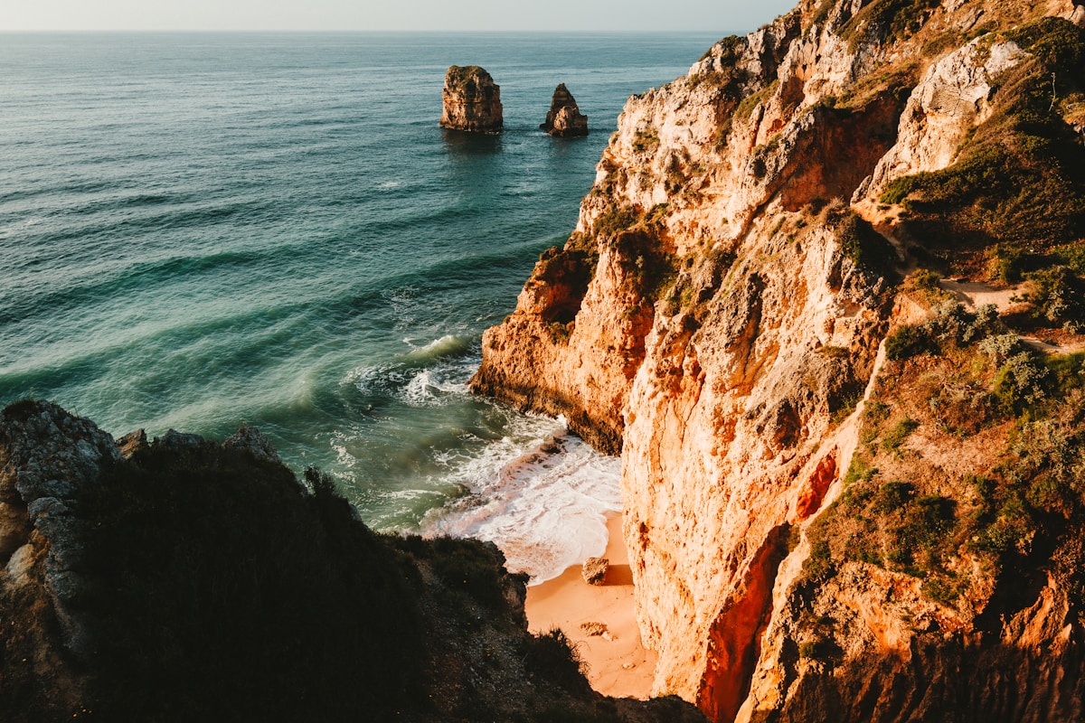
Karaburun Peninsula
The Karaburun Peninsula extends north of the Çeşme Peninsula — a 40km finger of land between the İzmir Gulf and the open Aegean, relatively undeveloped with coastal trails and cliff walks.
Character: Maquis scrubland and limestone clifftops above the Aegean. Wild, relatively isolated — the antithesis of the Çeşme resort experience. Several remote coves accessible on foot.
Karaburun to Mordoğan trail: A coastal route between the main town (Karaburun) and the fishing village of Mordoğan — approximately 20km of coastal walking, 8–10 hours. The path follows the cliff above the sea for much of the route.
Difficulty: Moderate — no significant elevation but rough terrain and limited shade.
Transport: Bus from İzmir to Karaburun (60–80 minutes, ₺40–60). Return bus from Mordoğan.
Water: Carry 3+ litres — no reliable water on the coastal sections.
Çeşme Peninsula walks
The Çeşme Peninsula (80km west of İzmir) has several walking options in addition to its beaches and windsurfing.
Çeşme to Alaçatı: 12–15km across the peninsula, through agricultural land and light maquis scrub. Not a dramatic mountain route but a pleasant half-day connecting the two towns.
Boyalık headland: Short (3–5km) coastal walks around the Boyalık Bay area near Çeşme town — cliff paths above clear water. No elevation gain; good for relaxed coastal walking.
Çiftlikköy to Dalyan: A 10km coastal section with sea views and cove access. Less walked than the beach areas.
Bornova and İzmir plain walks
For urban walking without leaving the İzmir area, the Bornova district (northeast of the city centre) has the British-era botanical garden (Kültür Parkı), several parks, and the foothills of the Nif range accessible on day walks.
Kültür Parkı (Culture Park): İzmir’s large urban park — 422 hectares in the city centre, with walking paths, the Aegean Fair buildings, and green space. Not hiking, but useful for a morning walk.
Long-distance context
İzmir is not on a major long-distance walking trail — the St. Paul Trail runs further east (Perge to Yalvaç), the Lycian Way is 200km south (Fethiye to Antalya), and the Carian Heritage Trail covers the Muğla coast. Day walks in the İzmir area are standalone routes rather than sections of a longer trail.
Ephesus area trails: The hills above Selçuk (Ephesus) have walking options combining the ancient site with the surrounding landscape — particularly the Mount Coressus ridge above the city and the Magnesia on the Meander ruins to the east. Worth combining with an Ephesus day trip.
Day hike summary
| Route | Distance | Duration | Difficulty | Transport |
|---|---|---|---|---|
| Spil Mountain summit | 12–18km | 5–7 hrs | Mod–Strenuous | Bus to Manisa |
| Nif Mountain | 10–14km | 5–7 hrs | Mod–Strenuous | Bus to Kemalpaşa |
| Karaburun coast | 20km | 8–10 hrs | Moderate | Bus to Karaburun |
| Çeşme to Alaçatı | 12–15km | 4–6 hrs | Easy–Moderate | Train to Çeşme |
| Boyalık headland | 3–5km | 1–2 hrs | Easy | Train to Çeşme |
Practical information
Best season: April–May for wildflower coverage and moderate temperatures; October–November for clear air and harvest season. Summer is feasible only for early-morning starts.
Footwear: Proper hiking shoes for Spil and Nif (rocky terrain). Trail runners adequate for the coastal walks.
Navigation: Wikiloc and Maps.me have user-uploaded tracks for the Karaburun and Spil routes. The trails are not consistently waymarked — download GPS tracks before going.
Water: Carry 2–3 litres for mountain routes; 3+ litres for the Karaburun coast. The Çeşme Peninsula walks have cafes accessible.
For the Ephesus area, see coastal towns near İzmir for the day trip logistics.
Planning your hike: Browse tours and activities in İzmir for guided hiking experiences around İzmir — a local guide adds context to the trails and ensures you don’t miss the best routes. Travel insurance covering outdoor activities is worth checking before you head out.
Frequently Asked Questions
- What hiking is possible near İzmir?
- The most accessible hiking from İzmir is at Bozdağ (120km east, 2,159m), which has a ski resort in winter and forest trails in summer. Nif Mountain (Kemalpaşa, 45km east, 1,510m) is closer and has a day-hike circuit through oak and pine forest above the İzmir plain. The Çeşme Peninsula has coastal walking on the headlands above the Aegean — flat, short routes with sea views. Mimas Mountain (Karaburun Peninsula, 90km) has remote coastal paths.
- Can you hike at Ephesus?
- The Ephesus archaeological site has a set walking circuit (2–3 hours) through the ancient city — this is archaeological walking rather than nature hiking, but the scale and completeness of the site make it a significant physical experience. The Bülbüldağı (Mount Prion) ridge above the theatre has a path to the Temple of Domitian and the upper city; the Panayırdağı (Mount Koressos) ridge has a path to the Grotto of the Seven Sleepers. Both are short hikes with genuine archaeological rewards.
- What is the Karaburun Peninsula like for hiking?
- The Karaburun Peninsula (90km west of İzmir) is one of Turkey's most unspoiled coastal landscapes — a largely undeveloped finger of land running southwest into the Aegean, with maquis scrub, dramatic sea cliffs, small fishing villages, and clear water. Marked trails are limited; the coastal driving route (via Mordoğan, Karaburun town, and Sarpıncık) has stops for coastal walks on the headlands. Accessible by car only — no public transport to the peninsula's further reaches.
Ready to explore?
Browse hundreds of tours and activities. Book securely with free cancellation on most options.
Browse on GetYourGuide →We may earn a small commission — at no extra cost to you.